Concept prototype · 20X study · Not the official SGL website
Point cloud terrain with contour lines resolving behind a survey flight line
●  Sander Geophysics · Airborne survey, worldwide

The earth, read from the air.

Sander Geophysics Limited (SGL) provides worldwide airborne geophysical surveys for petroleum and mineral exploration, and geological and environmental mapping. This is that work, drawn as it flies.

Founded1956, Ottawa Line kilometres15M+ flown AIRGrav accuracy0.2 mGal RMS StatusCurrently flying
01 / The company

One company: aircraft, instruments, processing, interpretation.

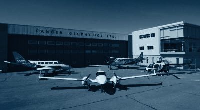
SGL was founded in 1956 to provide ground geophysical surveys. Airborne surveys began in 1958 and have been the main focus since 1967. The head office and aircraft maintenance hangar are located at the international airport in Ottawa, and the company has operated on every continent, including Antarctica.

Nearly one third of SGL's resources are devoted to developing new and more efficient instrumentation and techniques. The aircraft, the sensors and the processing live under one roof, which is why the data reads the way it does.

More about SGL →

SGL head office and hangar in Ottawa, Canada
FIG 01 · Head office and hangar, Ottawa. Photo: SGL, shown in the 20X duotone treatment
0
Founded, Ottawa
0
Aircraft owned and operated
0+
Full time employees
0M+
Line kilometres flown
03 / AIRGrav

Gravity, measured at survey speed.

AIRGrav, the Airborne Inertially Referenced Gravimeter, is the only purpose-built airborne gravimeter currently flying commercial surveys. The gravimeter sits on a three axis inertially stabilized platform with high resolution Differential GPS, so it stays far less affected by horizontal accelerations than systems built from modified sea gravimeters.

Accuracy is 0.2 mGal RMS throughout, in offshore work, over rolling terrain, and on loose drape over high mountains above 3,000 m.

AIRGrav in detail, with the field probe →

0
mGal RMS accuracy
0
km2 per day, fixed wing
0
Line km, Turner Valley case
0
mGal noise, Turner Valley
04 / Safety record

150,000 hours of survey flying. No aircraft accidents or serious injuries.

SGL has flown and compiled more than 15 million line kilometres of high resolution airborne geophysical data since 1956, all of it with no aircraft accidents or serious injuries. SGL is a founding and accredited member of the International Airborne Geophysics Safety Association (IAGSA).

How SGL flies safely →

05 / Latest

Currently flying.

All news
August 2026 · Nova Scotia, Canada

High resolution survey over various parts of Nova Scotia

Sander Geophysics has been selected to fly a magnetic gradient and radiometric airborne geophysical survey over extensive parts of Nova Scotia. Survey flying has commenced in eastern Cape Breton.

June 2026 · Ireland

Flying completed for the major project in Ireland

SGL has completed the last flight collecting magnetic, electromagnetic and natural radioactivity data for this extensive project, which began in 2011 and provides detailed geophysical data for the whole country.

January 2026 · Guinea, West Africa

Airborne geophysical survey in Guinea

SGL has been selected to fly an airborne geophysical survey in the eastern part of Guinea, launched at an official ceremony in Conakry under the World Bank supported geoscience program.